| World’s longest sea-crossing bridge - Hong Kong-Zhuhai-Macao Bridge opens in 2018 | ||
|
|
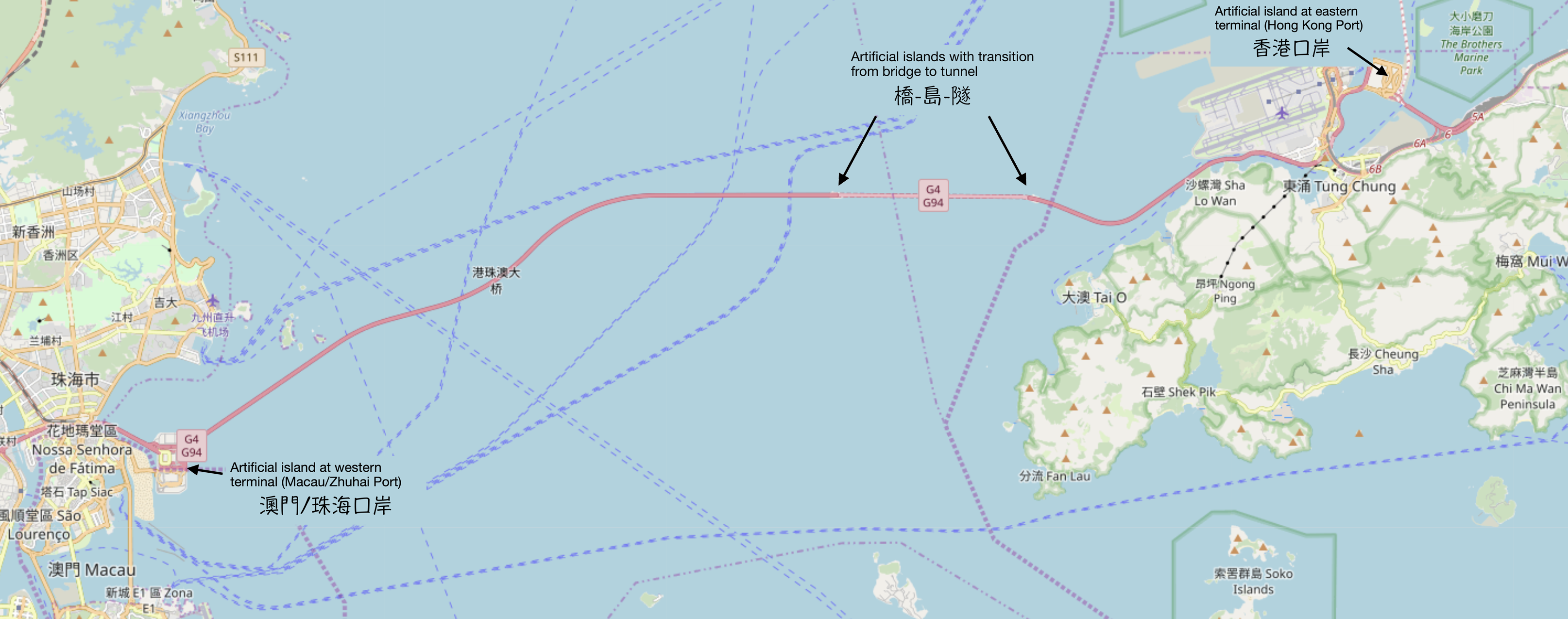
The Hong Kong-Zhuhai-Macao Bridge was officially opened on October 24, 2018. It is ranked as the world's longest cross-sea bridge. The bridge spans the Lingting Sea, on the mouth of the Pearl River Estuary, mainly connecting Hong Kong, Zhuhai and Macao. With a total length of 55 kilometers, it took nine years to complete this arduous project. The bridge was built to last 120 years, assuming no significant sea-level increase. The main purpose for building this bridge was to shorten the traveling time from/to Hong Kong to/from Zhuhai and Macao; without use of the bridge, traveling between Zhuhai and Hong Kong by land takes around 3 hours, while by sea high-speed ferries take about 70 minutes. The Hong Kong-Zhuhai-Macao Bridge reduces the travel time to only 30 minutes by crossing the bridge (assuming no traffic jams). Planners expect this expressway to be very beneficial to these three places for boosting their economies. In the early bridge construction plan, many voices from the world of civil engineering and groups in society offered suggestions. Engineers were especially cautious in the route layout, considering the driving time and type of the bridge. First of all, the sea territory transversed by the bridge is the habitat of the Chinese white dolphins, and is counted as an ecological conservation zone. Thus, the construction had to avoid harming the life of white dolphins or producing environmental pollution around the marine creatures during the construction work. Secondly, there are a lot of vessels in and out the Lingting Sea, and construction needed to avoid blocking in the water way. The sea-crossing route runs near the Hong Kong International Airport, so the design had to ensure that the height of the bridge tower would not threaten flight safety. In response to some of these considerations, large pieces for bridge body and most components were fabricated off-site in advance, then transported to the the construction site and assembled there. This method reduced the working time in the site, which lowered the disturbance to the natural environment. The use of a bridge-island-tunnel solved the problem of flight safety and water way traffic flow. The chief engineer who was in charge of the main bridge was Fanchao Meng and the chief engineer who was in charge of island and tunnel construction was Ming Lin. The team accomplished this challenging work.
What is a bridge-island-tunnel project? The entire structure of this bridge combines bridges, artificial islands, and a undersea tunnel. The west end point of the Hong Kong-Zhuhai-Macao Bridge is next to the border crossing between Zhuhai and Macao, and the east end point is next to the Hong Kong airport; each ending point has a customs control check-point built on an artificial island where the local immigration bureau is located. The west end point splits traffic into the Zhuhai port and the Macao port. The east end point is called the Hong Kong port. If the passengers enter the bridge from the Zhuhai Port or the Macao Port, then they will first get on a 22.9 kilometers long main bridge before connecting to the part of island-tunnel-island section. This section is very close to Hong Kong International Airport. The design of island-tunnel-island offers open space allowing safe conditions for airplanes to take off and land in the airport, and it also allows vessel traffic in and out the sea without any obstacles. These two artificial islands at each end of the tunnel are each 100,000 square meters in size, and the undersea tunnel which is in-between these two islands is 6.7 kilometers long. After passing the Hong Kong airport, passengers from Zhuhai-Macao will enter the Hong Kong port at the easternmost point of the Hong Kong-Zhuhai-Macao Bridge. Construction used an innovative technique for the creation of the artificial islands making the transition between bridge and tunnel. Typically, if they were built from the traditional way, it would take around two to three years to complete the work, but they were built with 120 pieces of 22 meter wide and 50 meter heigh steel cylinders, with each one of these cylinders placed straight down to touch the seabed and filled in sand. These 120 cylinders were arranged one by one to form an island shape. The islands were completed in 7 months. The undersea tunnel was made up of 33 immersed tubes and were buried under more than 40 meters of sea water. The tunnel section is not bored through the mud, but lies just under the seabed (buried under mud).There are many sea crossing bridges in the world. Regarding the scale, technically none of them are as difficult as the Hong Kong-Zhuhai-Macao Bridge. The architectural model of the bridge-island-tunnel, can be compared with the Nordic Öresund Bridge which connects Denmark and Sweden for vehicle and rail traffic. The bridge is 16 kilometer long and the length of the immersed tunnel is 3.5 kilometers. There is also the Geoje Bridge in South Korea, which connects Busan and Geoje Island with a total length of 8.2 kilometers and the length of the immersed tunnel is 3.7 kilometers. |
|||
Links about Hong Kong-Zhuhai-Macau Bridge:
|
|||
| Back to the Geophysical Timeline: Earth, Moon, Rodinia, Proterozoic, Plate Tectonics, Phanerozoic, Paleozoic, Ordovician, Neutron, Milky Way, Hadean, Galaxy, Fossils, Cryogenian, Sun, Big Bang, Archean. | ||
|
Back to the Biological Timeline: terrestrial animals, trilobite, prokaryote, oxygen catastrophe, Metazoa, eukaryote. |
||
| Articles of Chinese history: oil well, abacus, compass, gunpowder, first dictionary, parachutes, wheels, paper money. | ||
|
Back to the World History Timeline in English |
||
| Back to the Historylines home page. | ||
|